 HREN


Google DeepMind opens PARDIG and SatWeave, the precipitation and satellite datasets behind WeatherNext 3Google DeepMind, WeatherNext 3의 바탕이 된 강수 데이터 PARDIG와 위성 모자이크 SatWeave 공개
Google DeepMind has opened PARDIG, a global precipitation dataset, and SatWeave, a mosaic of geostationary satellite imagery, the datasets behind its WeatherNext 3 weather model, as live feeds and historical archives. Any Google Cloud account can read them on Google Cloud Storage without an access request form, under CC BY 4.0. In the company's own evaluation, PARDIG's hourly precipitation detection skill beat IMERG-Final by more than 30% on light-to-moderate precipitation.Google DeepMind가 날씨 AI 모델 WeatherNext 3의 바탕이 된 전 세계 강수 데이터 PARDIG와 정지 위성 영상 모자이크 SatWeave를 실시간 피드와 과거 기록으로 공개했습니다. Google Cloud 계정이면 접근 신청서 없이 Google Cloud Storage에서 읽을 수 있고 라이선스는 CC BY 4.0입니다. 회사 자체 평가로는 약한 비부터 보통 비까지 PARDIG의 시간별 강수를 잡아내는 성능이 IMERG-Final보다 30% 넘게 높았습니다.
- Source published원문 게시일
- Checked확인일
Google DeepMind has released two datasets behind its WeatherNext 3 weather AI model: PARDIG, a global precipitation dataset, and SatWeave, a global mosaic of geostationary satellite imagery. The aim is to help researchers and developers build new weather, hydrology and climate applications, and both come as live feeds and historical archives. SatWeave gives the model a live view of developing clouds and storms, and PARDIG was used to train the model's precipitation forecasts.Google DeepMind가 날씨 AI 모델 WeatherNext 3의 바탕이 된 데이터 두 가지, 전 세계 강수 데이터 PARDIG와 정지 위성 영상 모자이크 SatWeave를 공개했습니다. 연구자와 개발자가 날씨와 수문, 기후 응용 프로그램을 새로 만드는 데 쓰게 하려는 것으로, 두 데이터 모두 실시간 피드와 과거 기록을 함께 냅니다. SatWeave는 WeatherNext 3에 발달하는 구름과 폭풍을 실시간으로 보여 주는 입력이고, PARDIG는 이 모델의 강수 예보를 학습시키는 데 쓴 데이터입니다.
SatWeave blends geostationary satellite imagery into one global mosaic across 17 visible, water vapor and infrared channels, bringing together satellites whose map projections, file formats, sensors and scan schedules, ranging from 10 to 30 minutes, make a coherent global map hard to form. Google DeepMind says that because SatWeave updates hourly, WeatherNext 3 can produce new global predictions, in contrast to models initialized on analysis data refreshed every six hours. Its historical archive spans over a decade. PARDIG (Precipitation AI Reanalysis: Densely Inferred GPM) is a precipitation map made by an AI model trained on spaceborne radar observations from the NASA Global Precipitation Measurement (GPM) Core Observatory, using SatWeave imagery and atmospheric fields from ECMWF as inputs, at 15-minute and roughly 10-kilometer resolution. Its historical archive runs from 1999 to 2026.SatWeave는 여러 정지 위성의 영상을 가시광선, 수증기, 적외선 17개 채널의 전 세계 모자이크 하나로 합쳤습니다. 위성마다 지도 투영과 파일 형식, 센서, 10~30분의 촬영 주기가 달라 하나의 지도로 맞추기 어려웠던 것을 합친 것입니다. 매시간 갱신되므로, 6시간마다 갱신되는 분석 자료로 시작하는 모델과 달리 WeatherNext 3가 새 전 지구 예측을 낼 수 있다고 Google DeepMind는 설명했습니다. 과거 기록은 10년이 넘습니다. PARDIG(Precipitation AI Reanalysis: Densely Inferred GPM)는 NASA GPM Core Observatory의 우주 레이더 관측으로 학습하고 SatWeave 영상과 ECMWF 대기 자료를 입력으로 쓰는 AI 모델로 만든 강수 지도로, 15분 간격에 약 10km 해상도입니다. 과거 기록은 1999년부터 2026년까지입니다.
Google DeepMind evaluated PARDIG itself against three continental radar networks in the US, Europe and Japan and over 36,000 weather stations worldwide. In the company's own evaluation, PARDIG improves hourly precipitation detection skill over NASA's IMERG-Final by more than 30% on light-to-moderate precipitation, outperforms it across all analyzed rain rates and is particularly effective at capturing extreme precipitation that existing global products find hard to detect. A comparison video in the blog post shows hourly rainfall during the July 2025 Texas Hill Country flash floods from NOAA MRMS ground radar (about 1 km), PARDIG (about 10 km) and IMERG-Final (about 10 km) side by side.Google DeepMind는 미국, 유럽, 일본의 광역 레이더 네트워크 세 곳과 전 세계 3만 6천여 곳의 기상 관측소를 기준으로 PARDIG를 자체 평가했습니다. 회사가 잰 값으로는 약한 비부터 보통 비까지 시간별 강수를 잡아내는 성능이 NASA의 IMERG-Final보다 30% 넘게 높았고, 분석한 모든 강우 강도에서 앞섰으며, 기존 전 지구 자료가 잡기 어려운 아주 강한 비를 잡는 데 특히 뛰어났습니다. 블로그의 비교 영상은 2025년 7월 Texas Hill Country 홍수 때의 시간별 강수를 지상 레이더 NOAA MRMS(약 1km)와 PARDIG(약 10km), IMERG-Final(약 10km)로 나란히 보여 줍니다.
Both datasets are openly available on Google Cloud Storage, and PARDIG's historical catalogs are also in Google Earth Engine. Any Google Cloud account can read them without an access request form, under CC BY 4.0. PARDIG is updated every 6 hours on Cloud Storage, with about 5 hours of average latency and about 2 to 8 hours of effective latency. Google DeepMind points to uses such as flood, landslide and drought models in regions without dense ground radar networks, as well as solar power and wildfire monitoring.두 데이터는 Google Cloud Storage에 공개돼 있고, PARDIG의 과거 기록은 Google Earth Engine에서도 열립니다. Google Cloud 계정만 있으면 접근 신청서 없이 읽을 수 있고, 라이선스는 CC BY 4.0입니다. PARDIG는 Cloud Storage에서 6시간마다 갱신되며, 평균 약 5시간, 실제로는 약 2~8시간 뒤에 반영됩니다. Google DeepMind는 지상 레이더가 촘촘하지 않은 지역의 홍수와 산사태 등을 다루는 모델, 그리고 태양광 발전과 산불 감시 같은 쓰임을 들었습니다.
PARDIG is an experimental dataset, and the documentation says it does not constitute official weather observations, forecasts, watches or warnings and points users to official alerts and advisories from their national meteorological service. The data includes material from agencies such as NOAA, EUMETSAT and JMA and from other third-party providers, and that material may come with its own terms.PARDIG는 실험 단계의 데이터이고, 문서는 이것이 공식 기상 관측이나 예보, 주의보, 경보가 아니며 공식 경보와 안내는 각 나라 기상청을 따르라고 적었습니다. 데이터에는 NOAA, EUMETSAT, JMA 같은 기관과 다른 제3자의 자료가 들어 있고, 그 자료에는 따로 붙은 조건이 있을 수 있습니다.
Keep reading더 읽기
All articles전체 글TencentTencent
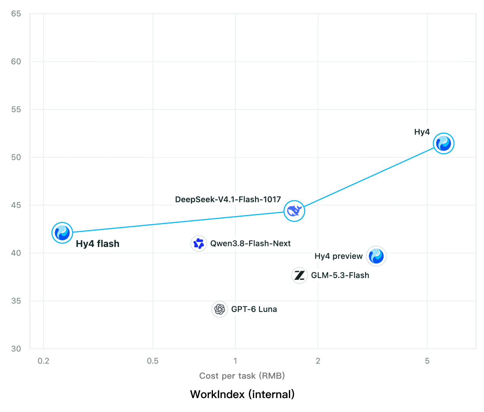
Tencent releases Hy4 flash as open weights, with FP8 and base versions, under the Tencent Hy LicenseTencent, Hy4 flash 가중치 공개 — FP8 · base 모델 포함, Tencent Hy License
Checked확인일
Chart: Tencent Hy4 flash model card. Tencent internal testing.그림: Tencent Hy4 flash 모델 카드. Tencent 내부 시험 결과입니다.
ElevenLabsElevenLabs
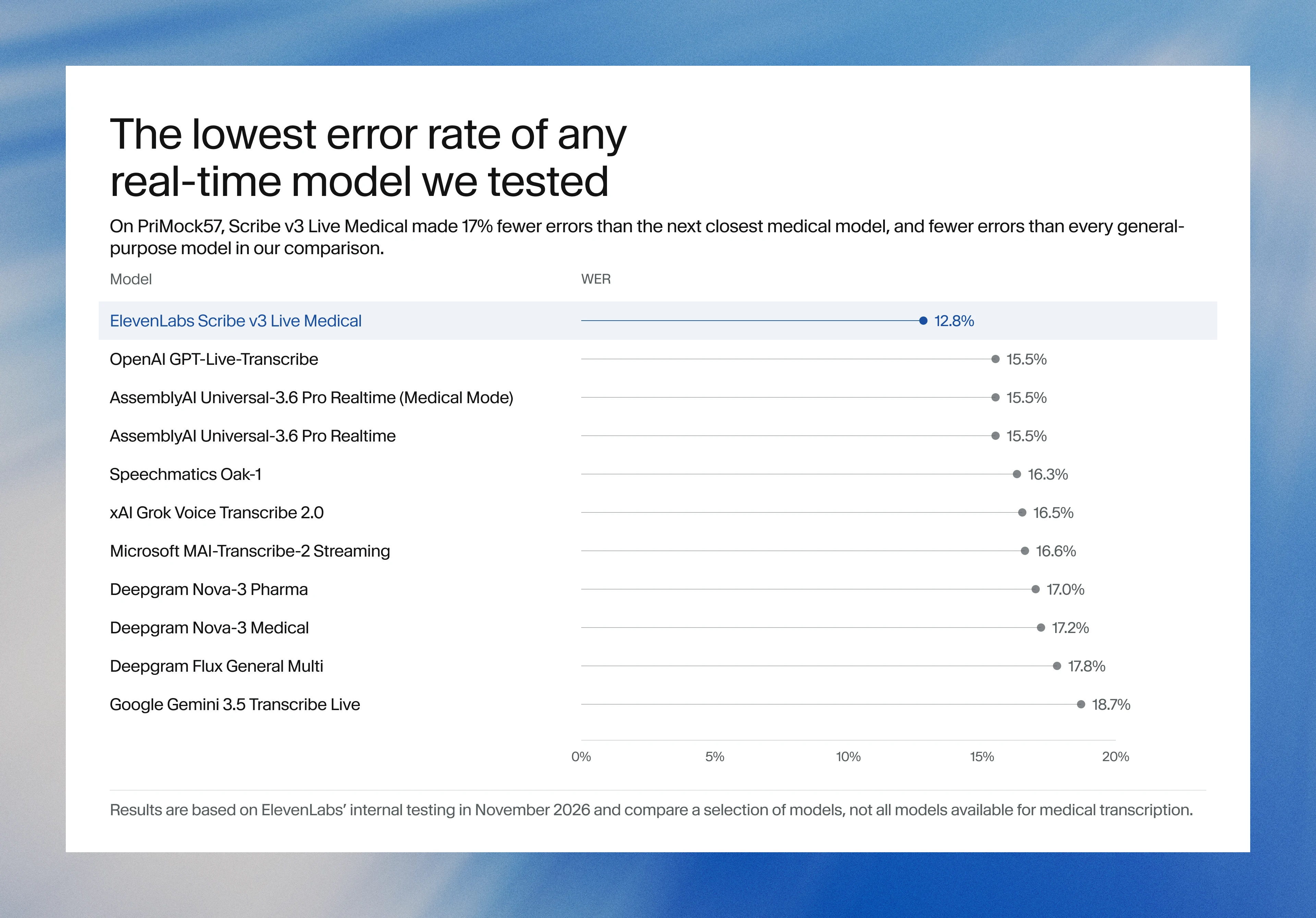
ElevenLabs releases Scribe v3 Live Medical, real-time medical transcription for voice agents in ElevenAgentsElevenLabs, ElevenAgents 음성 에이전트용 실시간 의료 전사 Scribe v3 Live Medical 공개
Checked확인일
Image: ElevenLabs blog.그림: ElevenLabs 블로그.
GoogleGoogle
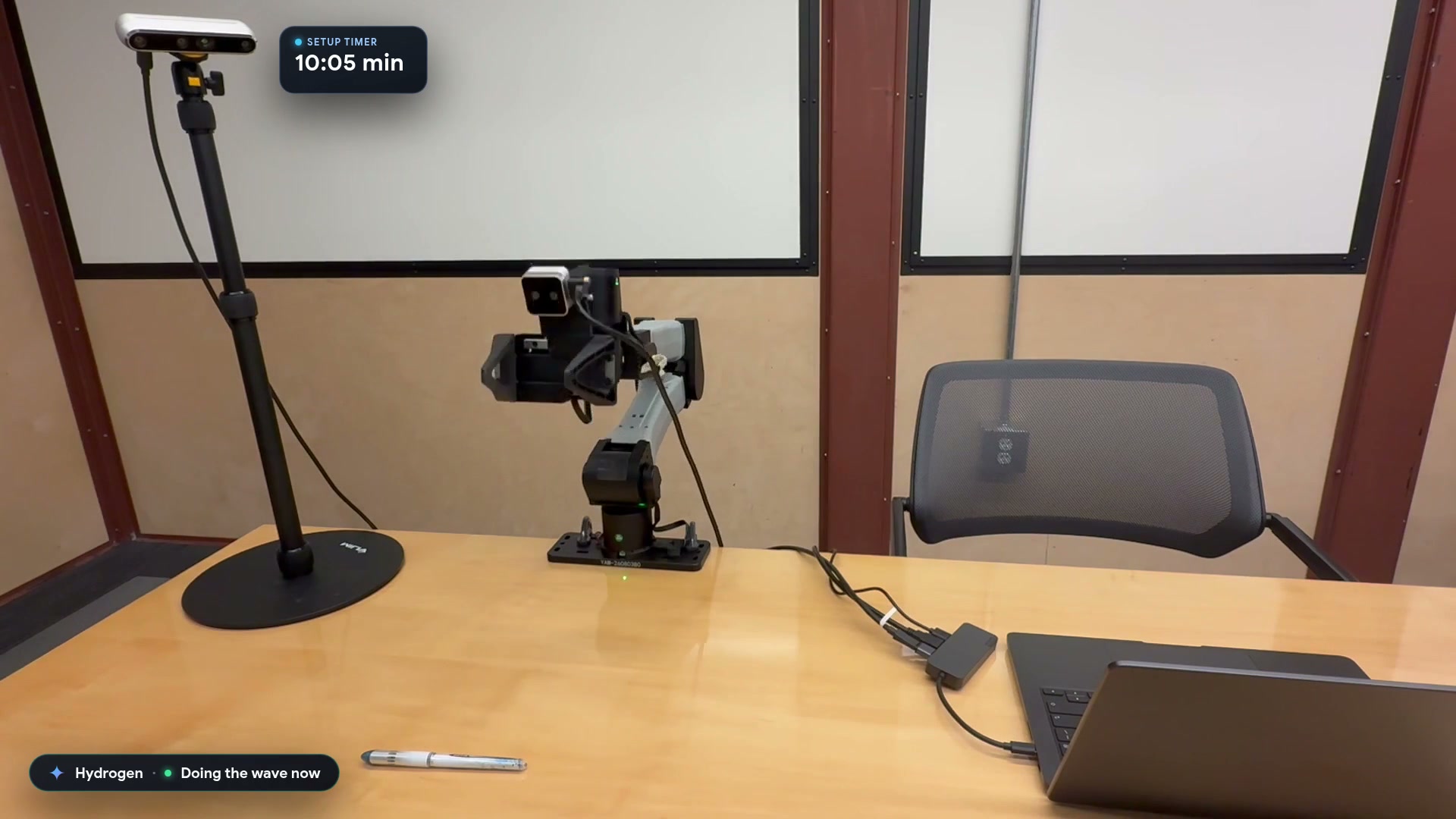
Google launches a Robotics plugin for Google Antigravity that sets up, simulates and controls robot arms with Gemini 4 HydrogenGoogle, Gemini 4 Hydrogen으로 로봇 팔을 준비·시뮬레이션·제어하는 Google Antigravity용 Robotics 플러그인 공개
Checked확인일
Video still: Google Developers Blog.영상 장면: Google Developers 블로그.